paddling

Blog

Queens Lake


No Comments

Hi everyone,

14 of us enjoyed a picturesque & tranquil paddle last Sunday which had a bit of everything starting with a beautiful 7 kms forest drive through soaring stands of timber to the wide expanses of Queens Lake & the more intimate environs of Bob’s & Limeburners Creeks which run off the lake.

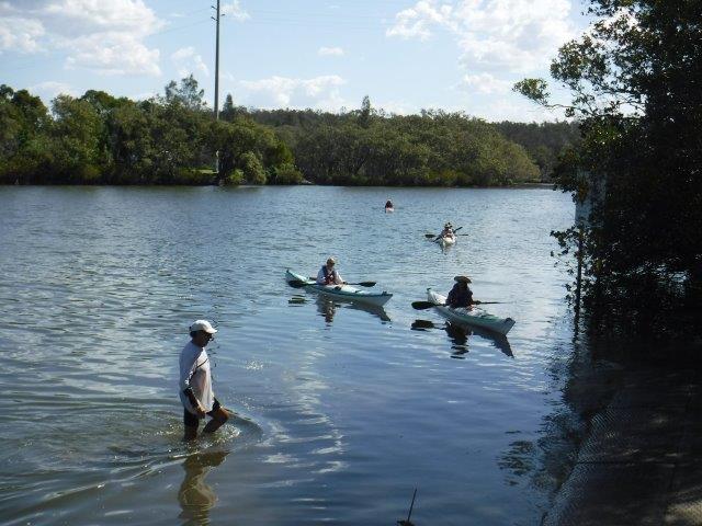
The drive into Queens Lake Nature Reserve along Bob’s Creek Rd. is one of the nicest rural roads you could find & along the way are very interesting historical signs detailing the history of the area with photos of original settlers, their homes & other interesting memorabilia. Every now & again clusters of tall, white trunks of ghost gums stood out from the shade of the forested areas. All the trees are ram rod straight & tall, an indicator of what the original timber in the area must have been like. Glimpses of Bob’s Creek could be seen through the lower vegetation with the sun illuminating the tanin coloured water. When we pulled into the reserve the lake in all its glory was an enticing sight through the trees along the shore. It was a clear, calm winter morning & the view across the lake from the little timber jetty was breathtaking, with North Brother perfectly reflected straight across the lake. After unloading & launching we paddled to our left up Bob’s Creek until stopped by timber blockages. Although just a short paddle it was beautiful & very atmospheric with tall trees surrounding us on either side & Mother Nature’s landscaping all around us.

Back out of the creek we paddled around the northern perimeter of the lake, past little rocky headlands, enjoying the vista all around us. While the other side of the lake is comparatively flat, heavily timbered banks with rocky sections climb steeply upwards on this side. We paddled across the openings of two small bays before entering Limeburners Creek which was lovely & easy to navigate. Last time we were there the water was covered with a dense carpet of casuarina leaves which made paddling almost impossible. We managed to get all the way up the creek, once again enjoying all the timber surrounding us, before heading back with the wide open spaces of the lake stretching out ahead of us with clouds & North Brother perfectly reflected in the dead calm water. All in all a very pleasant two hour paddle in perfect conditions.

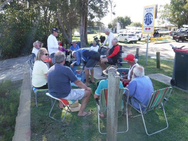
Back at the reserve we enjoyed a picnic lunch looking across the lake which was even more calm than when we were paddling.

The area around Queens Lake was declared open to free settlers & up to the 1850’s it remained the southern outpost of Port Macquarie with industries such as lime burning, cedar cutting & bush grazing being the main activities. In the late 1800’s the area was settled by a number of pioneer families, some of whose descendants are still in the district. They made their livelihood from timber. Trees were felled & conveyed to Herons Creek wharf & taken by steam punts to Laurieton. Eventually land was cleared & agriculture commenced with maize being the main crop. Gradually farming & dairying began. I have attached a photo of one of the original houses belonging to the Latham family.

If you are interested, take a drive out here, check our the historical signs & also take a detour down Roseneath Rd. which leads to Herons Creek Winery & the creek.

Thanks everyone for joining us & we hope you enjoyed the morning.

Cheers
Caroline

This slideshow requires JavaScript.

Blog

Saltwater Creek & Lagoon at South West Rocks


No Comments

Well the rain held off long enough for Bill V, Bill & myself to enjoy a very special paddle last Sunday on Saltwater Creek & Lagoon at South West Rocks.

This unassuming little creek is accessed from the beach just below the surf club & is a real gem. It is one of 130 estuaries in NSW & is classed as an ICOLL (Intermittently Closed & Open Lake or Lagoon ). Estuaries like this ( & Killick Creek at Crescent Head ) form the foundation of the coastal food chain & provide important habitats for a variety of marine & terrestrial plants & animals. There are 24 naturally occurring vegetation communities in this area.

The water is a darkish colour as a result of tanin from the melaleuca & other trees growing along the creek, & sometimes in inundated areas. It contrasts with the pale sand & rocks of the beach at its opening. Dunes & rising, sometimes rocky terrain features on the eastern side of the creek with flat areas on the town side. Initial views up towards Arakoon & the hills disappear as the trees close in, only to open up again when you emerge into the lagoon with Hat Head National Park in the distance.

Back in the creek the melaleucas have to be the contortionists of the tree world. Twisted trunks with flaking bark &  buckled boughs reach out across the water like bleached skeletons. Tall feathery topped grasses swayed in the breeze, forming moving corridors while the more rigid grass of the saltgrass meadows formed a dense carpet in places. We paddled under three footbridges & easily manoeuvred our way through the  arbour, enjoying the reflections, the seclusion & the myriad shapes of the fallen trees…a gallery of timber sculptures. I spotted several azure kingfishers darting through the foliage as well as groups of ducks & a lone swan trying to keep ahead of us. As we emerged onto the lagoon, which was teeming with birdlife, we encountered at least 30 black swans. But my biggest thrill was sighting a cormorant rookery on one of the little islands. I almost missed it as their nests & the birds themselves were perfectly camouflaged in the maze of white, bare branches of drowned trees.
We spent about two hours paddling along the creek & around the lagoon, exploring all the little ponds & shallow areas. It is an oasis in what is a popular sea change township.

After our paddle we adjourned to a sunny table at an outdoor café on the main street & indulged in coffee & their all day breakfast.

Cheers
Caroline

This slideshow requires JavaScript.

Blog

Gumma


No Comments

Six of us enjoyed a few pleasant quiet days up at Gumma last week. While it is always lovely at this reserve, the campground has been spruced up & a new amenities block is due to be built.

George & Betty, Colin & Marion, Bill & myself & ‘Billie’ ( our little dog ) enjoyed warm days & cool nights with only a little rain.

The mornings were crisp with light, ghostly water vapour rising up off the creek, highlighted by the morning sun. The days were balmy & blended seamlessly into cool evenings around the fire with a huge full moon rising up above the tree line casting a pale light   across the camp. As night descended on the campground, cloaking everything in shadows, the chilling cry of a solitary catbird, the lonely honking of swans, the shrill shrieks of plovers & the background hum of night insects provided nature’s soundtrack for the evening. During the night, the sound of the surf crashing in the distance across the creek echoed across the reserve. It was a quiet camp, not crowded & perfect for a relaxing few days.

We did some paddles close to Gumma itself which was good training for Billie who is still on her paddling ‘L’ plates, but showing all the signs of becoming a proficient paddling pooch!! It is picturesque paddling & brought back memories for George, Betty, Bill & myself of the first time we explored Warrell Creek many years ago now.  Both Bill & Colin paddled up past Scotts Head & Bill paddled down to the opening at Nambucca & found the landscape very different to what we have seen in the past. There is a largish bay now where we used to pull over onto the sand bank & the sand has also extended out & across from the other side. Bill also paddled up to the road bridge & was rewarded with the sighting of a huge osprey & a sea eagle. The wedge tailed eagle’s nest is still there, but Bill did not sight him. Bill & I & Billie paddled from Talarm up to Hells Gate which was beautiful, particularly right on the high tide. We then enjoyed a free hot shower & lunch at The Pub With No Beer at Taylors Arm. This is a quiet neck of the woods ( only the local dogs wandering around ) with a few classic old cottages.

Back at Gumma we were treated to the sight & sound of a group of about 12 black swans on the creek, as well as two smaller groups which did daily fly overs. They look so elegant gliding along.

Thanks to those who joined us; we trust it was an enjoyable break.

Cheers
Caroline

This slideshow requires JavaScript.

Uncategorized

Pipers Creek


No Comments

What fantastic paddling last Sunday; Pipers Creek at its best.

As we drove in, the sleepy hamlet of Kundabung was coming alive with the Sunday markets being set up at the old hall. The enjoyment of this paddle for me starts with the drive into the reserve along the lovely winding dirt track through the tall trees with glimpses of the sheltered creek through the vegetation.
The calm, cool morning was perfect for paddling & enjoying the gorgeous reflections & creekside landscaping.

We split into two groups; the larger group, led by Greg, paddled the picturesque & meditative upper section of Pipers Creek & then Smiths Creek. They reported being able to navigate further up both these sections than we have in the past. The smaller group, led by Bill, paddled downstream enjoying the wider part of Pipers Creek with jaw dropping reflections showcased in the morning sunlight. At the end we turned left into the Maria River & paddled up to its junction with Connection Creek (approx. 24kms return). The last km or so of this section the river narrowed & with the overcast conditions that had come across throughout the morning the river & surrounding forest looked & felt isolated & remote, setting all your senses working & making you want to stop, listen & scan  the vegetation, like you were being watched from amongst the foliage. Tall trees towered above on both sides with cascading vines coming all the way down to the water. Elk ferns could be seen on many tree trunks & there was a great variety of vegetation.  It is an interesting stretch of water & on this day an atmospheric section of the river which links up our well known paddles on Pipers & Connection Creeks & the Upper Maria.

The whole area has an interesting history. In 1831 Surveyor James Ralfe discovered a stratum of limestone of superior quality about 6 miles from the head of navigation of Pipers Creek ( thought to be names after one Captain Piper). Between 1832 – 40 lime kilns were constructed ( most probably by convict labour from Port Macquarie). These kilns, now heritage listed, were referred to as Bonnie Corner Lime Kilns or Smiths Creek Lime Station. They are located in the Kumbatine NP 12 kms south of Kempsey & west of the highway. Cells were built in the area of the kilns where the convicts were locked up at night. The limestone burned up there was conveyed down to a loading wharf at Kundabung by low wagons with wooden wheels drawn by a team of convicts. It was then loaded onto barges & convicts rowed them down to Port Macquarie. Here it was used in the building industry, at least up until the 1880’s. (Every now & again heritage tours of the remnants of the kilns are conducted by National Parks & Wildlife. If you get a chance, go on one as its is fascinating. I have included a photo I took years ago on such a tour).

The first settlers in the district were all engaged in the timber industry & logs were brought out of the bush on skids & then hauled by horses to the wharves on either side of where Smiths Creek enters Pipers Creek. The logs were then transported by log punt to Hibbards Mill in Port Macquarie.

The early settlement was referred to as Smith’s Creek, but following the opening of the railway , people started a village close to it & the name proved unsuitable. It was renamed Kundabung ( meaning Black Apple tree in the local language) which was also applied to the railway station & the school which opened in 1909 & closed in 1967. There have been several timber mills in Kundabung over the years.

Although the four paddlers who did the longer option got back just as everyone else was finishing up, we could not resist having a campfire for awhile as it is almost club tradition to do so at Kundabung.

We hope everyone enjoyed their paddle. Thanks Greg & Bill for leading. Hope you have a safe & happy Easter break.

Caroline

This slideshow requires JavaScript.

Blog

Ghinni Ghinni Creek


No Comments

Last Sunday was another perfect Autumn morning & 16 of us rolled up at Coopernook for the always popular paddle on Ghinni Ghinni Creek to The Other Side Café.

The morning was calm, cool & sunny & the end of daylight saving was an added bonus. I always enjoy a bit of a Sunday drive thrown into the mix so The Eagles were on my playlist this time; cruisy & laid back. Bill cycled down again & this week beat the ‘sag wagon’ (me) in!

Seven of us did the paddle around Jones Island & met up with the rest of the group ( & Kate who cycled in the vicinity )for coffee & cake at the café.
As our group paddled down the Lansdowne River we saw some lovely reflections on the water, perfectly intact as there was little or no breeze to disturb the surface of the water. This option took in the broad expanse of the mighty Manning River which on this morning was like a mill pond & stretched out before us like a sheet of glass. We paddled past oyster leases, waterfront properties, & Scotts Creek which runs down to Farquhar Inlet at the Tasman Sea. The Manning is the only double delta river in the Southern Hemisphere & Farquhar is described as an intermittent entrance. The other entrance is at Harrington Inlet. Its Aboriginal name is Boolumbahtee (Biripi) & translates as ‘a place where brolgas play’. The Manning rises at Mt. Barrington, is 261 kms long & interestingly is described  one of only a few Australian mainland rivers to receive annual winter melting snow deposits (Wikipedia).

After paddling past the village of Croki, which still has remnants of its original timber wharf, we continued along until we veered across the river & entered Ghinni Ghinni Creek. It was nice to see the welcoming red patio umbrellas & gable roof of The Other Side Café pop up ahead of us & we hauled our kayaks onto the bank & headed up the steps for morning tea. The other group were not far behind & after somehow getting 15 kayaks up onto the narrow bank we were all ready to devour coffee & delicious cakes – apple strudel ( sorry Gerg!!), hummingbird, sticky date & more. It was relaxing sitting in the café garden under the trees, looking at all the whimsical decorations including old wrought iron bed ends turned into a flower garden, quirky pottery, tree trunks wrapped up in crochet & old timber chairs hanging from trees. These chairs reminded me of stories & drawings depicting the ducking of suspected witches. In medieval times until the early 18th century, ducking was used as a way to establish whether a suspect was a witch. Ordeal by water was associated with the infamous witch hunts of the 16th & 17th centuries; an accused who sank was innocent while floating indicated witchcraft!
Back on the water it was pleasant to paddle in & out of narrow bands of shade in the cool as the day was warming up. A few of us did a quick detour into Dickensons Creek – an arm of Ghinni Ghinni-which we have not ventured into before. It is narrow & pleasant & looked like it went on for a distance, but we turned back after a km to join up with the main group. There were plenty of birds around including spoonbills, herons, ibis & kingfishers & a huge old fallen tree is now a permanent part of the creek’s landscaping.
Ghinni Ghinni means ‘mud crab’. In the 1880’s sailing ships would go up the creek picking up corn from the farmers. A big plank would be put out to load the corn onto the ship. The local baker, butcher & grocer also used to travel up the creek by boat selling their wares.

Back at Coopernook the pub carpark had filled up with lots of motorbikes out for a Sunday run. After loading up it was time to relax in the shade next to the river & enjoy a picnic lunch. Thanks Brad & Maria for the watermelon which went down a treat & to Greg for leading the main paddle.

Hope you enjoyed the day.

Cheers
Caroline